MY VOLCANIC ISLAND

MY VOLCANIC ISLAND
Photo gallery

ICELAND GEOLOGY
Iceland geology is characterized by its dynamic and diverse natural features, shaped by the interactions of tectonic plates and volcanic activity. The country is situated on the Mid-Atlantic Ridge, a boundary between the North American and Eurasian tectonic plates. This unique geological setting contributes to Iceland's geological phenomena, making it a land of glaciers, geysers, hot springs, and volcanoes.
VOLCANIC ACTIVITIES
Iceland is one of the most volcanically active regions on Earth. The country experiences eruptions approximately every 4-5 years on average. While some eruptions are small and localized, others can have broader implications, impacting air travel and even global climate.
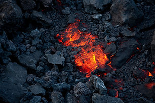
Photo gallery from volcanic eruptions 1973, 2010 and 2021

VESTMANNAEYJAR
The Vestmannaeyjar volcano, also known as Eldfell, is situated on the island of Heimaey in the Vestmannaeyjar archipelago off the southern coast of Iceland. Eldfell gained international attention in 1973 when it unexpectedly erupted, threatening the town of Vestmannaeyjar. The eruption began on January 23, and the island's residents were forced to evacuate to mainland Iceland.
EYJAFJALLAJÖKULL
The Eyjafjallajökull eruption in 2010 captured global attention due to its widespread impact on air travel. he eruption of Eyjafjallajökull began on April 14, 2010, following increased seismic activity in the preceding weeks. The volcano is located in southern Iceland, beneath the Eyjafjallajökull glacier. The eruption produced a massive ash cloud that reached high altitudes in the atmosphere. The fine ash particles posed a significant threat to aircraft engines, leading to widespread flight cancellations across Europe for several days.

FAGRADALSFJALL
Fagradalsfjall, located on the Reykjanes Peninsula in southwestern Iceland, gained attention in 2021 due to a volcanic eruption. Fagradalsfjall's volcanic activity became prominent in March 2021 when a fissure eruption began in the Geldingadalur valley. This event marked the first eruption in the area in over 800 years, capturing global interest.
Vestmannaeyjar
Pictures that my father captured during the eruption. He was there as an engineer assessing the structure of buildings. 1/3 of the fishing village went under volcanic ash. These pictures where captured with slides film


Eyjafjallajökull
Pictures captured both from the glacier and from surrounding area when Eyjafjallajökull erupted 2010


Fagradalsfjall
Pictures captured by me during the eruption 2021


